A) Lobito to Luanda
B) Matadi to Kinshaa
C) Dar-es Salaam to Mombasa
D) Kampala to Mombasa
Show Answer
The correct answer is D .
Which of the following irrigation schemes is the most successful in Nigeria?
Options:A) The Kiri Dam Project
B) The Zobe Dam Project
C) The Kainji Dam Project
D) The Kano River Project
Show Answer
The correct answer is D .
A) freezing point
B) dew point
C) atmospheric point
D) boiling point
Show Answer
The correct answer is B .
A) Anhular, sand and clay
B) Rounded, irregular and flat
C) rounded pebbles and silt
D) Sand, loam and clay
E) Angular, prismatic and columnar
Show Answer
The correct answer is D .
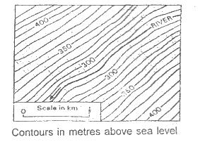
The shape of the valley on the map above may be described as
Options:A) U-shaped
B) Flat-shaped
C) Meandering
D) V-shaped
E) Braided
Show Answer
The correct answer is A .
A) orbit
B) latitude
C) axis
D) longitude
Show Answer
The correct answer is B .
A) wind erosion
B) glacial activity
C) volcanic activity
D) folding
E) river deposition
Show Answer
The correct answer is D .
A) completion of useful folder crops
B) soil and wind erosion of pasture land
C) epidemic of cattle diseases
D) scarcity of good pasture land.
Show Answer
The correct answer is C .
A) volcanic eruption
B) earthquake
C) hurricane
D) coastal erosion
Show Answer
The correct answer is C .
A) sandstone
B) slate
C) Chalk
D) Clay
Show Answer
The correct answer is C .