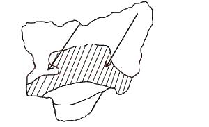
A) Mediterranean
B) Temperate evergreen
C) Tundra
D) Tropical monsoon
E) Temperate grassland
Show Answer
The correct answer is C .

The total annual rainfall received within the shaded area ranges from
Options:A) 301 cm to 400 cm
B) 201 cm to 300 cm
C) 50 cm to 100 cm
D) 101 cm to 200 cm
Show Answer
The correct answer is D .
Remnants of folded structures are found in the?
Options:A) Fouta Djallon Highlands and Eungu Scarp
B) Adamawa Highlands and Akwapim Hills
C) Fouta Djallon Highlands and Adamawa Highlands
D) Akwapim Hills and Eungu Scarp
E) Adamawa Highlands and Eungu Scarp
Show Answer
The correct answer is C .

A profile drawn along M-P east of Parko - Ego road on the map describes a
Options:A) Ridge
B) Scarp
C) Concave slope
D) Convex slope
E) Broken ridge
Show Answer
The correct answer is C .
A) Bilharzia
B) Dysentery
C) River blindness
D) Cholera
Show Answer
The correct answer is A .
A) Egbin
B) Shiroro
C) Ijora
D) Afarn
Show Answer
The correct answer is B .
A) thermometer
B) barometer
C) hygrometer
D) anemometer
Show Answer
The correct answer is D .
A) high mortality
B) even distribution
C) water pollution
D) redistribution
Show Answer
The correct answer is D .
A) Near a regular source of flour
B) In an area of cheap labour
C) Near a large market for bread
D) Near a source of good clean water
E) Near a regular source of electricity
Show Answer
The correct answer is C .
A) squatter settlement
B) dipersed settlement
C) linear settlement
D) nucleated sttlement
Show Answer
The correct answer is D .